These charts are from the UK Met Office in Exeter which is the nation’s central hub for weather and climate forecasting. It houses the Met Office’s supercomputers, forecasting teams, and operations centre responsible for issuing the UK’s official weather forecasts and severe weather warnings. The Exeter site also leads major climate‑science research and supports aviation, marine, and international meteorological services. They will each open a new tab n your browser.
The charts below show the Previous 24 Hours UKMO MSLP Analyses and are the Met Office’s surface‑pressure charts from the last four synoptic times (00z, 06z, 12z, 18z). They show how pressure patterns, fronts, and weather systems have evolved over the past day, helping you track recent developments before looking at the forecast charts.
The forecast charts (MSLP Analysis) are the Met Office’s latest surface‑pressure maps, created from real observations at the main synoptic times (00z, 06z, 12z, 18z). It shows the current positions of highs, lows, and weather fronts across the North Atlantic and Europe, providing the starting point for all the forecast (prognosis) charts that follow on the page.
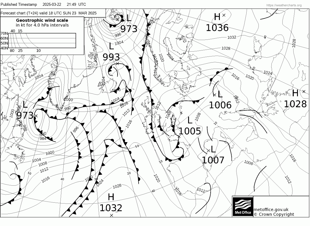
The T+24 Prognosis chart shows the Met Office’s forecast surface‑pressure pattern for 24 hours ahead. It builds on the latest analysis to illustrate how highs, lows, and frontal systems are expected to evolve over the next day..
The T+36 Prognosis chart shows the expected surface‑pressure pattern 36 hours ahead, highlighting how developing systems are forecast to shift between the short‑ and medium‑range periods.
The T+48 Prognosis chart provides a two‑day‑ahead view of evolving highs, lows, and frontal zones, helping illustrate how current features are likely to organise and move across the North Atlantic and Europe.
The T+60 Prognosis chart offers a forecast of the surface‑pressure pattern 60 hours into the future, bridging the gap between early and mid‑range guidance and showing the progression of key weather systems.
The T+72 Prognosis chart provides the projected surface‑pressure pattern for 72 hours ahead. It offers a medium‑range view of developing weather systems, showing how current features are likely to shift and intensify over the coming three days.
The T+84 Prognosis chart presents the projected pressure pattern 84 hours ahead, giving a clearer sense of medium‑range trends such as deepening lows or expanding high‑pressure areas.
The T+96 Prognosis chart shows the expected surface‑pressure layout four days ahead, offering insight into broader synoptic developments and the likely evolution of major weather features.
The T+120 Prognosis chart provides a five‑day‑ahead outlook, illustrating the longer‑range progression of pressure systems and giving an early indication of potential large‑scale weather patterns